Our first port of call this morning was the visitor centre to check on the trail conditions. It sounded like it would be fine to hike the trails without traction devices. There would be some snow and ice near the top, but we were told that even if we slipped, we were highly unlikely to fall into the canyon – reassuring! We had to catch the shuttle bus to the South Kaibab trailhead as no private cars are allowed down that road even in winter.
There are two main trails that go down into the canyon – the Bright Angel Trail and the South Kaibab trail. The Bright Angel is probably the more well known, but we chose the South Kaibab as it has far better views of the canyon. The plan was to hike to Ooh Aah Point, about a mile into the canyon. The first part was pretty snowy and icy, but there was enough dirt and mule poop mixed in with it that it wasn’t slippery. The South Kaibab trail is very steep especially at the beginning. It descends around 100m vertically very quickly on a series of switchbacks down a section called “The Chimney”. Once we were past there the track opened out and the views were unbelievable.
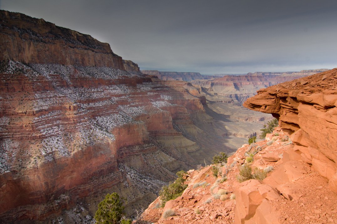


The Grand Canyon is spectacular from up on the rim, but to truly appreciate the vastness of it you need to go down. Hiking into the canyon was even better than we imagined. It’s impossible to find words to describe it and even photos can’t capture the experience.


It didn’t take long to get to Ooh Aah Point, where the views were Ooh Aah. The temptation to go down further is very strong, as hiking down is fairly easy. There are warning signs that say “CAUTION, Remember that down is optional but up is mandatory”. The Ooh Aah Point hike was rated moderate and the next point down at Cedar Ridge was rated difficult. We couldn’t resist though and carried on to Cedar Ridge, about 350 vertical metres below the rim.
The hike to Cedar Ridge was amazing. It went along the top of a ridge that jutted out into the canyon so the views were fantastic. At one point the track went along a ridge about 6 feet wide with sheer drops on either side. Surprisingly it didn’t feel unsafe. Each side of the track was bordered by rocks which formed a low wall and gave a sense of security. Cedar ridge was a surprisingly large flat area, a good place for a decent rest away from the edge. We didn’t stay too long though as we had only brought enough snacks for the Ooh Aah Point hike.


Hiking back up was hard work, but not as bad as we had feared. We definitely puffed more at the higher altitudes, but recovered quickly after short rests. There were a few compulsory rests when we got stuck behind mule trains. The mules had to have frequent rests, just like us!
We were pretty hungry by end of our adventure, but really happy that we had gone the extra distance down to Cedar Ridge. It was still very mild weather so we were able to have a picnic, something I didn’t imagine we’d be doing at Grand Canyon in winter!
After a quick rest back at the hotel, we headed out to Hopi Point on Hermits Rest road for the sunset. Not a particularly good sunset, but still amazing to have one last look at the canyon. We branched out at dinner with a visit to a Mexican restaurant. Later in the evening Anna and I had a game of 10-pin bowling. Our hotel has an arcade and 10-pin bowling alley on the basement which seems to be the social hub of Tusayan.


Sounds like all is going to plan. Even the weather is obliging! I see as usual Matt isn’t feeling cold!! Hope the expedition in the morning goes well. Love xx